Weather, winds and route to Brazil
The mammoth challenge that awaits me as I mentally prepare for my Ocean X odyssey offers a rather simple, yet complex question: when is the best weather and correct time to kayak across the Southern Atlantic?
It would be virtually impossible to kayak across an ocean if the elements are not in your favour and the most important weather elements to consider are the winds and currents. Failing to prepare leaves me with no option but to prepare to fail and even that theory can be quashed by the sudden change in the elements of Mother Nature.
The Southern Atlantic Ocean is dominated by the South Atlantic subtropical high pressure, which basically sits over the middle of the ocean. In the centre of the high pressure there are generally calm winds and variable winds. Moving outwards the wind speed and direction become greater and from a more constant direction
I’ll be departing from Cape Town and those who live and grew up in the fairest Cape know that during the winter months the cold fronts (low pressure systems) bring the north-westerly winds that create big sea swells and lots of rain.
The direction that I will be heading on my journey from Cape Town to Brazil is in a North-Westerly direction so trying to paddle into a headwind during the winter months would be futile. I’d be wasting a lot of time and energy for hardly any gain.
South Easterly Winds
During the summer months though, the opposite happens as the South Atlantic high moves South and pushes the cold fronts downwards and away from Cape Town. Summers here in the Cape are normally dominated by the South Easterly winds that blow in the direction that I want to pursue in achieving my Ocean X dream.
A week after leaving Cape Town it is highly likely that I will move into an area of consistent South Easterly winds known as the Trade Winds. These winds blow in an arc around the high-pressure system, thus helping me towards Brazil.
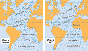
The ocean winds are also the main driving force of the ocean currents and they generally follow the direction of the winds, so waiting for the summer months will again work in my favour. ‘Timing is everything’ as they say in life.
One thing about ocean currents is that they do not move in a perfectly straight line. There are lots of what is termed as ‘eddies’, which is a circular current of water. It will be very important for me to not get stuck in the bogey counter-currents known as ‘eddies’.
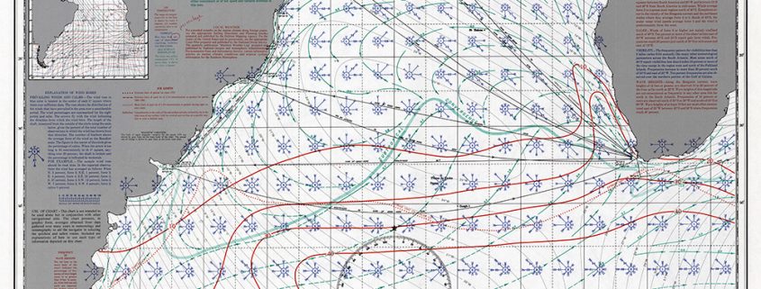
When sailors – and now kayakers – plan for an ocean crossing, they use what is known as routing charts. There are routing charts for every month of the year, which indicates the average conditions that could be expected for a given month using empirical recorded data over the past 20 years.
Southern Atlantic routing chart for January
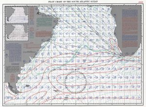
On the right-hand side of this chart there are detailed overviews of the temperature, wind, visibility and the wave heights.
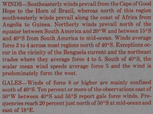
As you can read from the image above of the wind description, the South East wind is the most dominant between the Cape of Good Hope and the Horn of Brazil – a good time to be kayaking over 6000kms across the ocean!
A routing chart also includes several smaller inserted charts as seen in the image below.
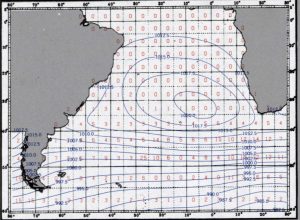
As you can deduct from the gales and pressure the red numbers in the centre of each square show the average percentage of ship reports in which winds of at least Force 8 have been recorded. The blue lines show the average barometric pressure at sea level.
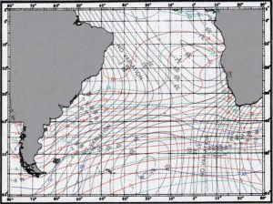
This chart shows the mean air temperature in Celsius in the red line showing every 2 degrees. The blue lines show the percentage of observations reporting visibility of less than 2 miles and the green lines are the average sea surface temperature in Celsius and show for every 4 degrees.
Wind Rose
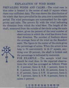
Every 5 degree square on the routing chart includes a Wind Rose. Above is the explanation of the Wind Rose. A cursory glance of the Wind Roses between Cape Town and Brazil show the South East arrow is the most dominant, which compares with the general wind description as indicated earlier.
But if you take a closer look at the Wind Roses around Cape Town you will notice there is a fair amount of wind blowing from other directions.
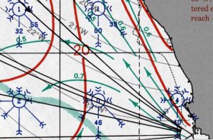
The most problematic wind for my departure would be the South West and Westerly winds, which could potentially blow me on to the shore wreaking havoc before I have even left the fairest Cape!
I will have to wait for a weather window that has about five or six days of Southerly and South East winds that will enable me to get North / a little bit West, so if I do encounter any winds from the West I would have made enough sea room to keep me from being blown on to the shore.
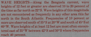
The other thing to note are the thick red lines that indicate the percentage frequency of having wave heights greater than 12 foot.
This brings me back to the beginning where I posed question: when is the correct time to kayak across the Southern Atlantic?
It would be virtually impossible if the elements are not in your favour and the window period for me to achieve my ultimate goal is December to the end of February when I can look forward to catching that treasured glimpse of South American land.
Keep paddling!



Leave a Reply
Want to join the discussion?Feel free to contribute!